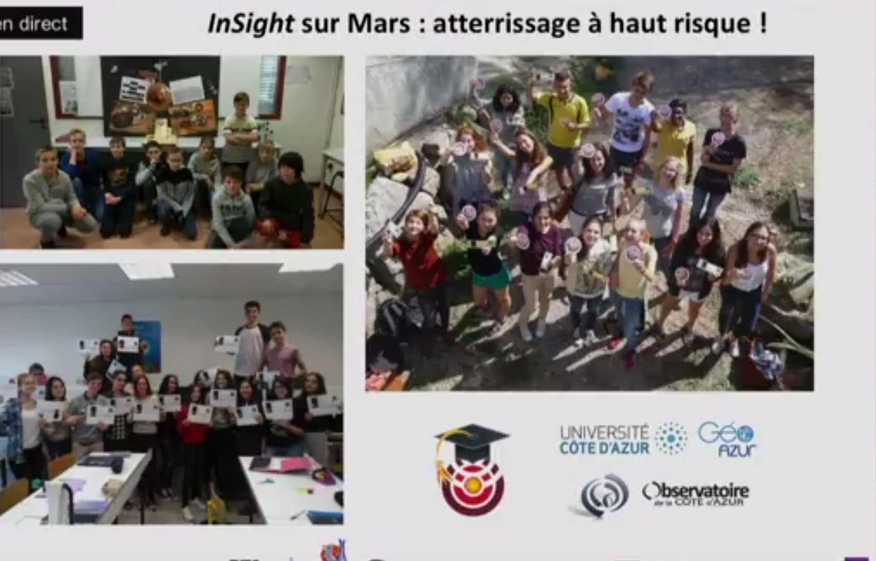
SOL 485 / UNE ANNEE MARTIENNE avec INSIGHT à l'ECOLE /A MARTIAN YEAR with INSIGHT at SCHOOL
A l'occasion du premier anniversaire martien de la mission InSight, les écoles font le point sur ces deux années de suivi de la mission / For the first Martian anniversary of the InSight mission, the schools feedback of the two years of mission.
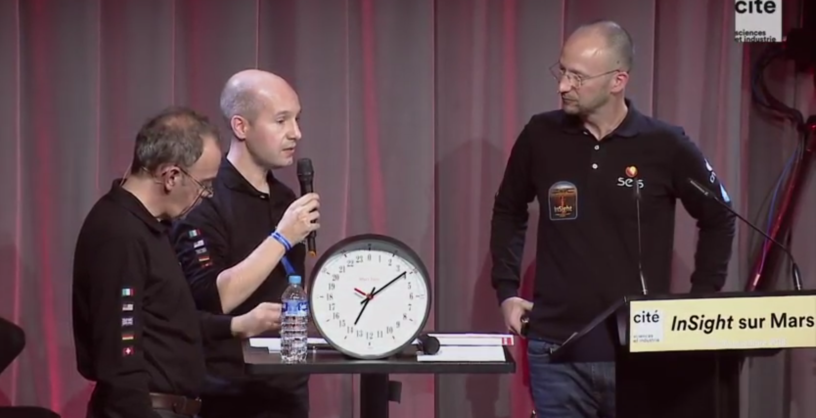
Télécharger la présentation (240 Mo)
SOL 199 / 19 JUIN 2019 : Mars tremble / Mars quakes !
SEIS a déjà enregistré quelques évènements dont le plus important est de magnitude 3. Les séismes sont classés en fonction de leur visibilité sur les tracés arrivant sur Terre. En effet, en fonction de la magnitude du séisme et aussi l'agitation thermique autour du sismomètre, les séismes ne sont pas enresgitérs avec la même qualité. Le séisme le plus important jusqu'à présent a été estimé à magnitude 3.
SEIS has already recorded some events, the most important estimated at magnitude 3. Earthquakes are classified according to their visibility on the records arriving on Earth. Indeed, according to the magnitude of the earthquake and also the thermal agitation around the seismometer, earthquakes are not recorded with the same quality. The largest earthquake so far has been estimated at magnitude 3.
SOL 128 / 7 AVRIL 2019 : A l'écoute du premier séisme enregistré sur Mars / First marsquake recorded by SEIS
C'est un signal faible, mais essentiel. Le sismomètre français Seis (Seismic Experiment for Interior Structure), déployé sur la planète rouge dans le cadre de la mission américaine InSight, a capté, le 6 avril dernier, son premier séisme martien, a annoncé mardi 23 avril le Centre National d’Etudes Spatiales (Cnes). "C'est fantastique, ce sont des choses qui n'ont jamais été faites. On a entendu la terre bouger", se réjouit auprès de franceinfo Charles Yana, chef de projet en exploitation de la mission au Cnes.
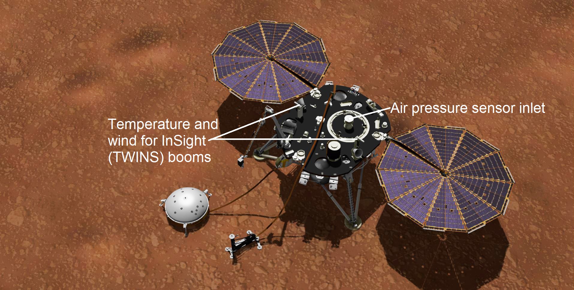
19 FEVRIER 2019 > QUEL TEMPS FAIT-IL sur ELYSIUM PLANITIA ?
La station météo InSight est en place à présent avec son baromètre (situé sur le lander) et deux capteurs de température et de vent. Sous le lander un magnétomètre (mesurant le champ magnétique local susceptible d'influencer SEIS) complète la station de capteurs géophysiques
InSight's package of weather sensors, called the Auxiliary Payload Subsystem (APSS), includes an air pressure sensor inside the lander — its inlet is visible on InSight's deck — and two air temperature and wind sensors on the deck. Under the deck's edge is a magnetometer, provided by UCLA, to measure changes in the local magnetic field that could also influence SEIS.
12 FEVRIER 2019 > Prêts à prendre la température de Mars !
Le lander InSight a déposé son second instrument sur le sol martien, la sonde HP3. Les dernières images confirment que l'instrument, chargé de mesurer le flux géothermique de Mars, a été déployé avec succès. L'instrument est situé à environ 1 mètre de SEIS et devrait enfoncer la sonde à 5 mètres de profondeur ... ce qui constituerait un record technologique sur Mars.
NASA's InSight lander has placed its second instrument on the Martian surface. New images confirm that the Heat Flow and Physical Properties Package, or HP3, was successfully deployed on Feb. 12 about 3 feet (1 meter) from InSight's seismometer. HP3 measures heat moving through Mars' subsurface and can help scientists figure out how much energy it takes to build a rocky world. Equipped with a self-hammering spike, mole, the instrument will burrow up to 16 feet (5 meters) below the surface, deeper than any previous mission to the Red Planet.
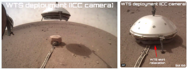
SOL 66 / 02 FEVRIER 2019 > CHAPEAU !
Telle une soucoupe volante, le dôme protecteur du sismomètre SEIS de la sonde est venu se poser en douceur à la surface de Mars.
La jupe a déjà commencé à se relaxer ! A noter que la dépose du WTS est une opération complexe, et les équipes analysent un grand nombre de données (position du WTS par rapport au sismomètre, performance thermique du bouclier, niveau de bruit sous cloche, etc.).
Like a flying saucer, the protective dome of the SEIS seismometer of the @NASAInSight probe has gently landed on the Martian surface.
On the ICC camera pictures of NASA InSight, the extendable skirt of my protective shield is not yet fully deployed, but is slowly starting to relax !
03 JANVIER 2019 > TROUVER LE NORD GEOGRAPHIQUE
D'un point de vue plus pratique, l'absence de champ magnétique global sur Mars pose un problème de taille quand on désire s'orienter. Dans ces conditions, comment trouver le nord ? Aussi paradoxal que cela puisse paraître, les scientifiques vont s'appuyer sur une technique ancestrale : l'utilisation d'un cadran solaire, converti en boussole.
Dans la Babylone antique, les hommes utilisaient déjà l'ombre portée d'un bâtonnet planté dans le sol pour déterminer l'heure. Des dizaines de siècles plus tard, InSight va employer cette technique sur la planète rouge. Au sommet de la protection thermique hexagonale cuivrée (RWEB) qui entoure le sismomètre SEIS se trouve effectivement une mire, au centre de laquelle se situe la poignée de capture, qui a permis le déploiement de l'instrument au sol par le grappin du bras robotique, et qui joue aussi le rôle de gnomon.
Pour déterminer avec précision la position du nord géographique de la planète rouge, et donc l'orientation du sismomètre SEIS, plusieurs images du cadran solaire vont être obtenues à des heures précises par la caméra IDC du bras robotique d'InSight. Un cliché sera ainsi pris à midi, un autre lorsque le soleil sera plus bas sur l'horizon, les ombres au sol étant alors plus longues.
The absence of global magnetic field on Mars raises a problem when we wish to find the North? The scientists are going to use an ancestral technique: the use of a solar dial, converted in compass.
In antique Babylon, people already used the projected shadow of a stick fixed in the ground to determine the hour. Dozens of centuries later, InSight is going to employ this technique on the red planet. At the top of the copper-colored hexagonal thermal protection ( RWEB) which surrounds the seismometer SEIS is actually a test pattern, in the center of which is situated the gnomon, which allowed the deployment of the instrument the ground.
To determine precisely the position of the northern geography of the red planet, and therefore the orientation of the SEIS seismometer, several images of the sundial will be obtained at different hours by the IDC camera of the InSight robotic arm. One picture will thus be taken at noon, another when the sun is lower on the horizon, the shadows on the ground being longer.
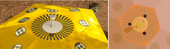
Au sommet de la protection thermique RWEB qui entoure le sismomètre SEIS, le crochet de préhension sert aussi de gnomon.L'ombre portée de la tige sur la mire permettra de connaître la direction et la hauteur du Soleil dans le ciel, et d'en déduire la position du nord géographique de Mars (© IPGP/David Ducros et © Marc Goutaudier)
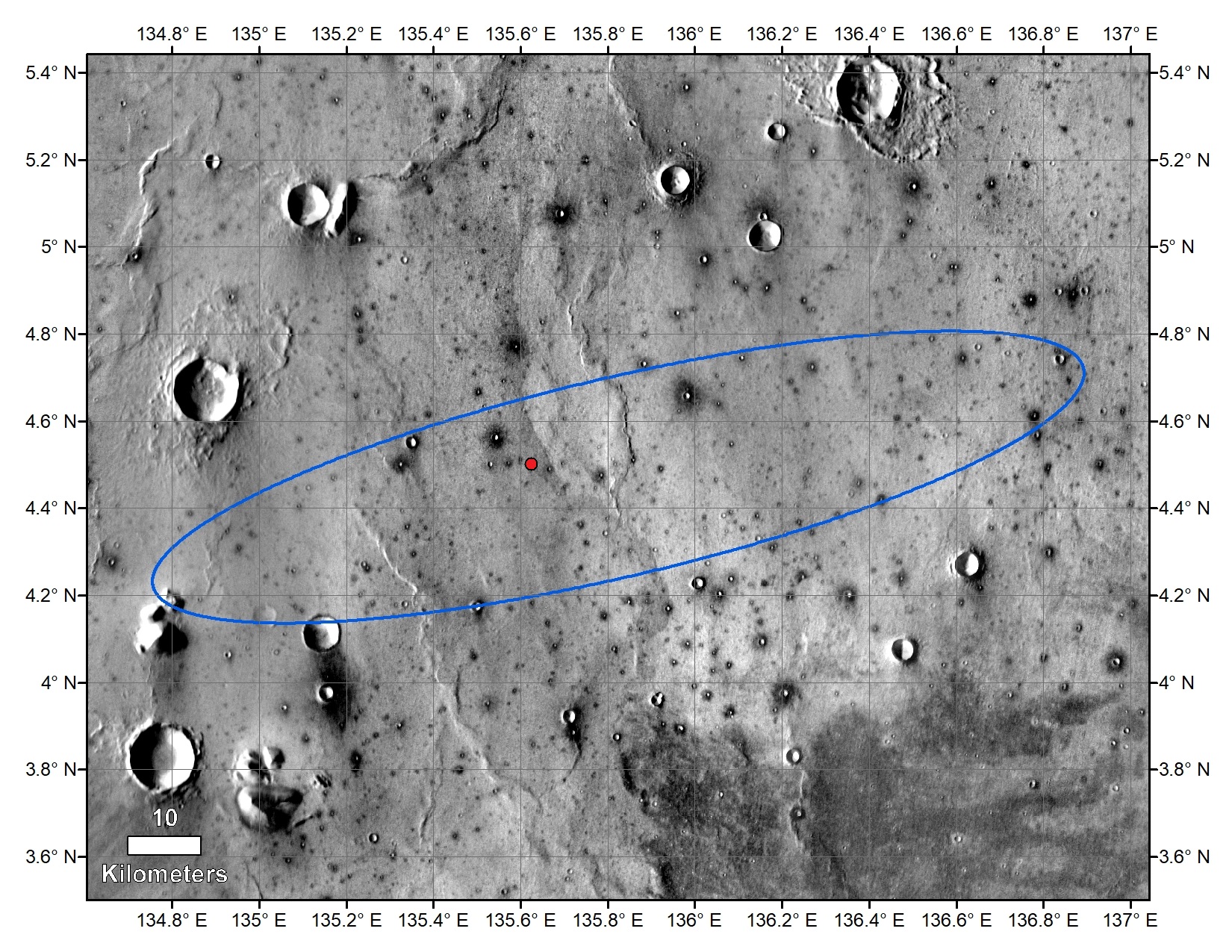
13 DEC. 2018 > LOCALISATION DU LANDER INSIGHT
Le point rouge situe le lander InSight sur cette image satellite prise par la camera THEMIS de l'orbiter Mars Odissey. L'ellipse représente la zone qui était prévue pour l'atterrissage (une éllipse de 130 kms de long et 27 kms de large). Mission réussie !
The red dot marks the final landing location of NASA's InSight lander in this annotated image of the surface of Mars, taken by the THEMIS camera on NASA's 2001 Mars Odyssey orbiter in 2015. The landing ellipse on this map covers an area within which the spacecraft had about a 99 percent chance of landing when targeted for the center of the ellipse. It is about 81 miles (130 kilometers) long, generally west to east, and about 17 miles (27 kilometers) wide.
01 DEC. 2018 > PREMIERS ENREGISTREMENTS DU LANDER
Le lander, qui a atterri sur Mars il y a une dizaine de jours, a enregistré les tous premiers bruits des vents Martiens sur la Planète Rouge. Les capteurs ont capturé un grondement sourd causé par des vibrations du vent, estimés souffler entre 10 à 15 kms/h (5 à 7 mètres par seconde), du nord-ouest au sud-est. Les vents étaient en accord avec la direction des bancs de poussière dans la zone d'atterrissage.
InSight, who landed on Mars about ten days ago, recorded any first noise of the Martian winds on the Red Planet. The sensors captured a noise caused by vibrations of the wind, estimated to blow between from 10 to 15 km/hour (5 in 7 meters per second), from the northwest to the southeast. Winds were in agreement with the direction of devil's dust in the landing zone.
26 NOV. 2018 > TOUCH DOWN !
Arrivée sur le sol martien réussi. InSight est sur Mars depuis 20:00 heures GMT. InSight s'installe sur Mars ! ... InSight at home !
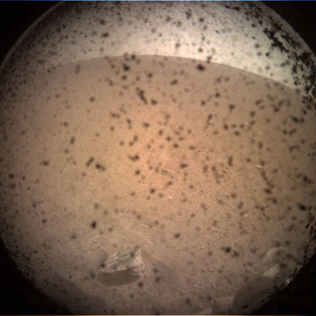
La zone autour du lander semble dégagée et propice au déploiement du sismomètre SEIS (qui n'aura lieu que fin décembre).
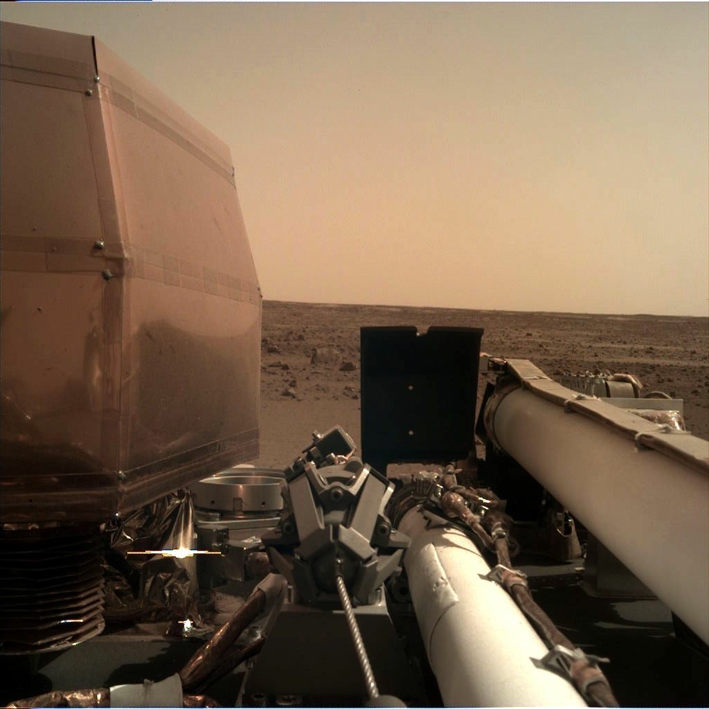
InSight must go on !... que l'aventure commence !
A la Cité des Sciences, l'équipe InSight Education, présente le volet Education de la mission InSight !
Retransmission de l'atterrissage en direct / Watch on line on NASA TV >
https://mars.nasa.gov/insight/timeline/landing/watch-online/
Depuis la Cité des Sciences, la retransmission française en direct des opérations d'atterrissage d'InSight >
https://www.youtube.com/watch?v=45grQ8RSLIU&feature=youtu.be
Calendrier prévisionnel des opérations
La durée de la mission InSight est prévue sur 709 sols soit 728 jours (deux ans environ)
L’exploration du site d’atterrissage a commencé par des opérations techniques à la minute où InSight s’est posé sur Mars (Plaine Elysium), mais la collecte de données scientifiques ne commencera pas avant 10 semaines.
Priorité aux panneaux solaires :
Une quinzaine de minutes après l’atterrissage, les moteurs de panneau solaire sont réchauffés et préparés pour déployer les panneaux solaires. C’est une opération importante qui va assurer au lander l’énergie nécessaire pour les opérations à venir.
Puis, il faudra scruter le site d’atterrissage :
Une semaine plus tard, le site sera scanné par les caméras embarquées, et une vérification du bras robotisé sera effectuée.
Et pourra commencer le déploiement des instruments :
On attend le déploiement du sismomètre (au bout de 3 ou 4 semaines), et plus tard (une a deux semaines plus tard) celui de la sonde thermique HP3.
Ceci est un exemple de calendrier des opérations à venir.
__
InSight's Mission Duration : 709 sols (Nearly two years on the Earth)
The InSight lander began surface operations the minute it landed at Elysium Planitia on Mars, but science data collection doesn’t start fully until about 10 weeks after landing. That's because InSight's science goals and instruments are very different from other Mars landers or rovers that have gone before. In some ways, InSight's science activities are more like a marathon than a sprint. The lander team must carefully select where to place the precious science instruments, which will be the first to study the interior of Mars.
First Things First: Solar Power
The dust from landing settled about 15 minutes after InSight made it to the surface. After this, the solar array motors warmed up and prepared to unfurl the solar panels. This is an important activity that ensured that the lander has all the power it needs to get to work on Mars. This, and other tasks on landing day take place autonomously, without human intervention.
What We Can Expect the First Few Weeks After Landing
Some science data collection begins the first week after landing. RISE, the Rotation and Interior Structure Experiment, begins collecting data a few days after landing. The lander will take pictures of the instrument deployment area, and start monitoring the weather and surface temperature at its new home. But since the heat probe and seismometer need to be on the surface of Mars to collect data, they have to wait a few more weeks before they can be fully deployed.
More details > https://mars.nasa.gov/insight/timeline/surface-operations